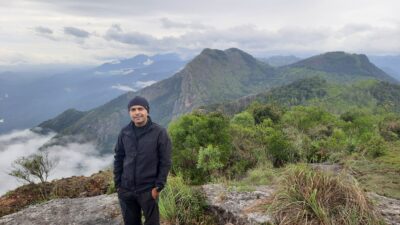
The Nilgiris, or “Blue Mountains”, are home to some of the most scenic, serene and enchanting landscapes in the southern part of the country. It is endowed with forests, tea gardens, meadows, valleys, waterfalls and lakes, all of which makes trekking in the Nilgiris a dream. In addition, the amenable weather throughout the year makes the region a trekker’s dream.
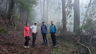
So, with a plethora of hikes and trails to choose from – known and unknown – it wasn’t long before I got my trekking shoes on and headed out to explore the Nilgiris. In this write-up, I’m sharing my experience of the 6 must-do treks in the Nilgiris. Some of them are not established trek routes, so I’ve attached maps for easy reference. I hope my experiences will serve as a ready reckoner for fellow hikers to plan their treks.
- Dodabetta Peak Trek
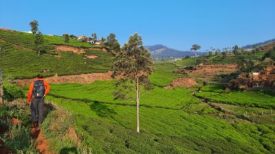
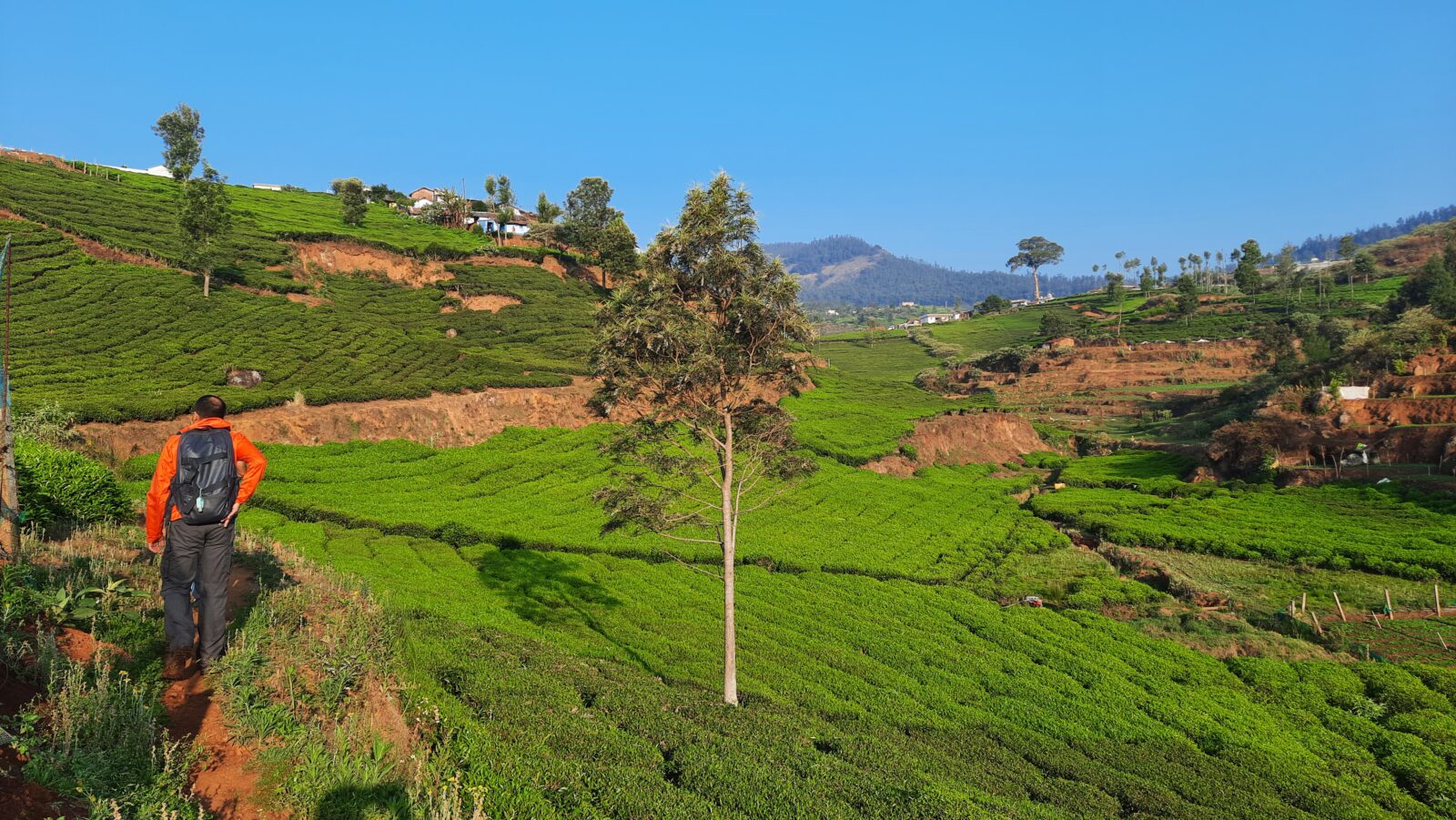
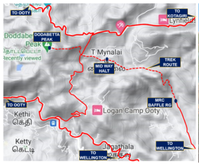
The Dodabetta Peak is the highest mountain in the Nilgiris, standing at an altitude of 2637 m. Located at a distance of 9 km from Ooty and 23 km from Wellington, its trek route from Wellington passes through picturesque tea gardens and forests. A moderately difficult trek with an elevation gain of 700 m approx, it takes 2.5 to 3 hrs to covers the distance of 6 km one way.
The starting point of the trek is from the Baffle Range in Wellington. The route traverses a a wide track that climbs its way along the left boundary of the firing range. Thereafter, it passes through a jeep track to make its way up towards the tea gardens located on the eastern slopes rolling down from Dodabetta Peak. With a splendid view of Wellington town waiting for you at the line of the tea gardens, the route continues through the tea gardens before entering a village named T Mynalai, where a short break can be planned in the village temple’s grounds. Thereafter, you are required to cross the link road that connects the Coonoor-Ooty and Kotagiri-Ooty roads. After you cross over, a jungle trail takes you through thick groves, dense undergrowth and occasional shrieks of wildlife. While traversing this portion of the route, it is important to keep a track of the correct direction in order to directly reach the top of Dodabetta Peak. Here, you can choose to either terminate the trek or climb back all the way down on the same route.
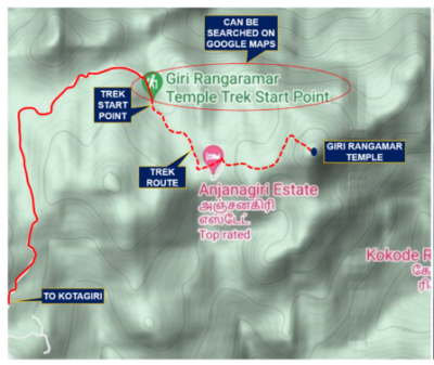
2. Giri Rangamar Temple Trek
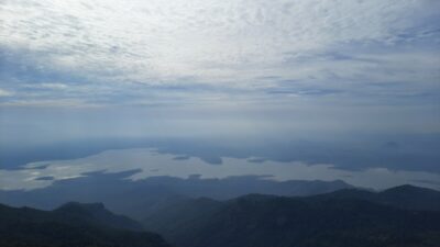
The trek derives its name from the Giri Rangamar temple located on top of the peak. Located at a distance of 43 km from Wellington, the start point of the trek is in a small village hamlet that can be searched on Google Maps. Trekkers are supposed to inform the village members before proceeding the climb for safety reasons. The trek route passes through a heavily forested area with a good chance of spotting wildlife if you are lucky. A moderately difficult trek with an elevation gain of 285 m approx, it takes 1 to 1.5 hrs to covers the distance of 2.5 km one way.
The route starts with a wide track that takes you inside a dense forest where a flight of steps lead up to the hilltop. The steps are slightly steep and may require you to stop to catch your breath before embarking on the climb that takes you to the temple. Once on the top, you will be greeted by panoramic views that begin with the Kodanad viewpoint on the left and the Moyar river valley, which drains into the upper Bhavani Sagar reservoir, on your right.
3. Catherine and Solai Falls Trek
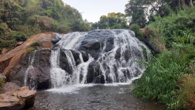
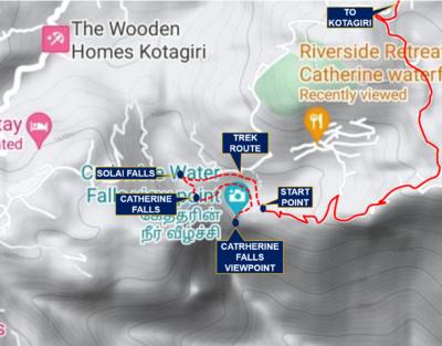
The trek to Catherine and Solai Falls is shorter comparatively. Located near Kotagiri at a distance of approx 32 km from Wellington, the twin falls are along the same stream. The trek route starts from a place close to the Catherine Falls view point (marked on Google Maps). With a fairly easy route except for a few steep slopes through the tea gardens, the trek has an altitude gain of 100 m over a total distance of 3 km, and takes approx 2.5 hr.
The trek route passes through the tracks in-between the tea gardens and leads to both the waterfalls. The Solai Falls are upstream, followed by the Catherine Falls at some distance downstream. The trek can be planned to any one of the Falls, and then you can travel upstream or downstream towards the other one. At the mouth of the Catherine Falls, you can witness the spectacle of water cascading down into the valley below. And at Solai Falls, you get a fantastic view of Catherine Falls and Lambs Rock (a popular tourist spot in the area) in the far distance.
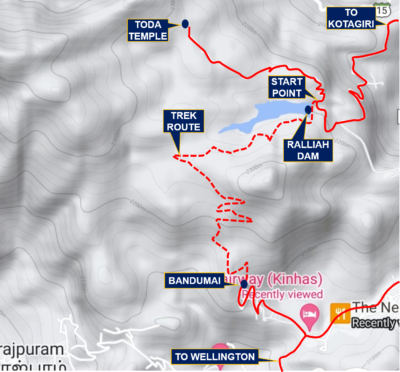
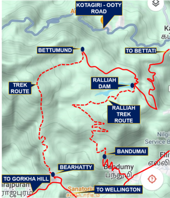
4. Ralliah Dam Trek
Ralliah dam is located on the road from Wellington to Kotagiri at a distance of approx 8 km. It’s a small dam, and is one of the sources of water for the town of Coonoor in the Nilgiris. The trek route is well marked and easy with a gradual climb that covers a distance of 4 km in approx. 1.5 hrs. The trek route starts from the dam site, which you need to cross to enter the forest around Ralliah dam. It’s a fairly easy route with a wide track that passes through a densely forested area and finishes at one end of Bandumai village, located along the Wellington-Kotagiri road. From Bandumai village you can walk down to Wellington or retrace your steps to return to Ralliah dam.
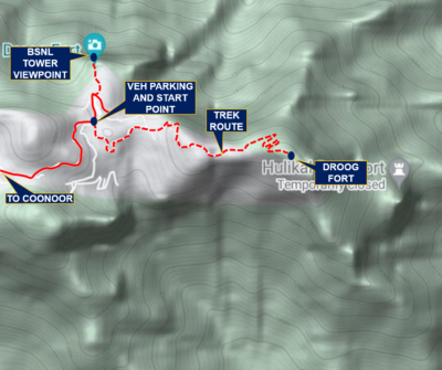
5. Droog Fort Trek
The Droog fort is located at a distance of 17 km from Wellington. The trek route takes you to an old dilapidated fort wall located on the edge of Pakkasuran Malai hill top overlooking the sprawling plains of Tamil Nadu. The moderately difficult trek traverses a distance of 2.6 km one way and takes approx 1 hr with an elevation gain of 265 m. The start point of the trek route can be searched on Google maps and it is well marked on ground as well.
The initial part of the trek passes through the geometrically aligned greens of a tea estate. After walking through the tea gardens, the route meanders and climbs along the forested slopes on both sides. The well marked route is mostly gradual except for the last portion where it passes through a dense jungle where a flight of stone lined narrow track leads you to the final climb. As you make your way to the top of the peak, the plains of Tamil Nadu appear to expand into the horizon and on a cloudy day you can witness gusts of clouds rising from the plains and crashing into the mammoth vertical invincible rock walls of the Nilgiris.
6. Bettumund Village Trek
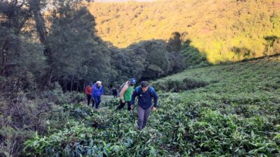
Bettumund village is a small hamlet located at a distance of 10 km from Wellington. It is home to the Toda people, an indigenous tribe believed to be of direct Dravidian descent. The tribe resides in small hamlets in the forests of the Nilgiris with one such village in the vicinity of Wellington. A moderately difficult trek with an elevation gain of 255 m, it takes approx 2 hrs to covers the distance of 2.5 km one way.
The route starts from Bearhatty village (it can be found on Google Map) and climbs up along a wide foot track along the forested slopes overlooking Wellington town. The first half of the route is a well-marked track, which leads to a small tea plantation patch. Thereafter, the route for the trek is through the forested slopes rolling down towards Ralliah dam and Bettumund village. It is very important to maintain the direction while traversing the forested portion due to the dense forest and thick undergrowth at places. Thus, the use of a GPS for navigation is recommended.
Important Advisory
It is important to mention that most of the routes given here are not established trek routes. They have been worked out with some help from Google Maps. The ones that are well established and well-marked are because they are undertaken by the DSSC, Wellington every year. Owing to the unexplored and not so frequented nature of the routes. it is advisable for fellow trekkers to go in a group of at least four to five persons as there are strong chances of encountering wildlife enroute. However, if one is cautious and follows the basic principles of trekking, then all these routes in the Nilgiris are fun to explore and provide a wide range of opportunities for the off roaders on feet.
Trek Essentials
- Water
- Rainproof Clothing (as it rains frequently)
- Trekking shoes
- Hiking Pole
- Refreshments (Food and drinks)
- Small Rucksack
- GPS (or a smartwatch with GPS)
- Be in a group of 3-4 as there are chances of wildlife encounters
Vibhor Tyagi
Vibhor and his better half Doorva are a vagabond couple who love exploring the paths that are less travelled. Close encounters with nature are what they do best, and towards that end they have gone on treks in J & K, Himachal, Uttarakhand, Arunachal, Karnataka, Maharashtra and Tamil Nadu.
Amazingly penned down. Very informative and helpful article for the trekking enthusiasts ❤️
Wonderful article. These trek paths in Nilgris are still not explored by general population in present world.Thanks to you people for giving valuable informations and encouraging people in exploring the hidden beauties of Nature.
Great Article Vibhor. Continue on these mesmerising trails and keep journaling to make amazing reads.
Womderful article with all the details.
Very informative.
Very illustrating and informative. A good read and indeed fills with motivation to go on these treks. Nilgiris are beautiful beyond words and these treks take it to another level.
Very informative and beautifully penned down. Thanks for sharing the details in a lucid manner.
Very well penned down sir. A good read and informative. Can be used as guide for enthusiastic trekkers.
Very well written article. Kudos to writer.
Hey Vibhor, thanks for writing this article. It definitely helps. I am Saransh and produce am a Travel Content Creator (@Xplore The Earth). And I am making a destination travel guide for Ooty. In addition to the most popular tourist spots, I want to suggest some treks and how to properly execute them. I would love it if I could have a dialogue with you. Email, text, call anything is fine. Let me know how can we connect.
Thanks in advance for your time!
Hi Saransh
You can reach out through WhatsApp on 8459783126